Sunday 14 February 2010

Birchover & Stanton Moor, Derbyshire

Todays walk was teeming with history. We drove about half an hour out towards Matlock to the small village of Birchover. The first place we saw was the Druids Inn. This is a highly recommended pub which is famed for it's food and somewhere I've been wanting to try for many years. Now that we know how to get there we'll have to go for an evening meal sometime soon. The Inn is so called because of the Druids who used to practice their magic amidst Rowter Rocks, immediately above the Inn. The rocks consist of several tunnels, with caves and carvings and is close to several prehistoric monuments including several stone circles on Stanton Moor.

Stanton Moor was the location of our walk today so we parked on the main road of the village. From the outset there was an unusual feel the village. It's only coming home that I've researched the area, and found out its unusual history, but the quaint cottages of the main road give the impression that they are occupied by modern day wizards, or hippies, or just people at one with the place. It wasn't an unsettling feeling, quite the contrary, everything just felt so 'right' about the place. I wish I had better words to describe it, but these will have to do. We came to a farm and followed the footpath through a farm and a field of, would you believe, Alpacas.

This is the route we took.


We started at Lees Road, taking the left hand fork up to the Nine Ladies Stone Circle. On the way to the stone circle we passed the Earl Grey Tower built by William Pole Thornhill dedicated to the Reform Act of 1832.


A short way past the tower we found the Nine Ladies Stone Circle. Its location is quite unusual as it is surrounded by woods, most stone circles are on the open landscape. Legend has it that nine ladies were turned to stone for dancing here on the sabbath. It really is a wonderful location and has the most tranquil of atmospheres. In fact for the rest of the walk I felt a deep sense of peace and a sense of having been somewhere almost magical. It was most unusual. A truly lovely place.


We walked through some open woodland and heather moors for a short while and came to the Cork Stone. This is one of a number of granite blocks remaining on the moor after the softer stones of the plateau had been worn down through the ages. It is 15 feet high has iron foot rests driven into it to aid climbing.


The area is very rich in archeological remains, especially Bronze Age, as well as having ecological and spiritual significance. It's a walk I will remember for a long time, and will certainly be researching further, and hopefully a few more return visits are in order.

This walk took us just under 2 hours and wasn't at all strenuous. I think we need something a bit more challenging next week though!

Sunday 7 February 2010

Derwent Reservoir

Today's walk was round Ladybower Reservoir - on the map below we followed the middle piece of water - from just to the left of Ladybower Inn up to Derwent Dam and back round the other side.


Ladybower is a fascinating place, not least because of what lies underneath the water. When the reservoir was built during 1935 and 1943, the villages of Ashopton and Derwent were 'drowned. Ashopton was completely demolished but Derwent Village was remained intact..

Here is a picture I found of the old church from Derwent Village. The clock tower of the church and some of the buildings were still visible some 14 year later when the reservoir was low. The tower has since been dismantled.


Ladybower was used during the Second World War by 617 Squadron for practicing the low-level flights needed for Operation Chastise, also known as the Dam Buster raids. There are still occasional fly pasts of the Battle of Britain Memorial Flights to commemorate this.

When we set off it this morning it was fairly clear and the water was still as anything. As we wound our way around the lake it got foggier and foggier and I was glad I'd used my camera earlier.

Here's a photo I took not far from the spot the photo above was taken.


Walking and Getting Fit

Me and Simon have just started to follow a walking regime. Partly to get us fit (we need it) and partly in preparation for the Shine Midnight Walk on 17th April on behalf of Cancer Research. It's good to have a goal to focus the mind but I hope we keep walking beyond April.


So far we're into week 3 which has involved 2 midweek walks of 3 miles, and a Sunday morning walk of 4 - 5 miles. As the weeks go on this will steadily increase until we hit our target 13 miler.

At the moment the midweek walks just involve walking around the town. Mainly because it's dark by the time we can get ourselves out, and we know where we're going. It's lovely to get out into the countryside on a Sunday though and we'll be picking a different location every week so look forward to seeing what is out there.


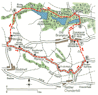
Last week we did our walk through Linacre Woods and Old Brampton in Chesterfield. Of course the walking also gives me an opportunity to take me camera out and about (as if it didnt need surgically removing anyway!) so I'll be posting a photo or two from our walks aswell.

Here's a map of our route - we hung a right at Bagshaw Farm and headed back to Linacre Reservoir.


Unfortunately Simon landed awkwardly coming over one of the styles and thinks he might have broken his little toe - so he's gonna have to take it easy on subsequent walks.

Here's a nice photo I took in Linacre Woods - it was a lovely sunny day and I caught the sun shining over the water and through the trees.